BIRMINGHAM, Ala. — Parts of Alabama were under the gun late Tuesday night as severe storms swept across the state, bringing tornado warnings, powerful wind gusts, and the threat of large hail and flash flooding. The most intense weather was concentrated in east and central Alabama, while other areas remained on alert as storms continued to develop.
According to the National Weather Service (NWS) offices in Birmingham and Huntsville, multiple tornado warnings were issued Tuesday night, with confirmed storm damage in at least five counties in north Alabama: Limestone, Madison, Colbert, Jackson, and Lawrence.
Tornado Watch in Effect for Central Alabama
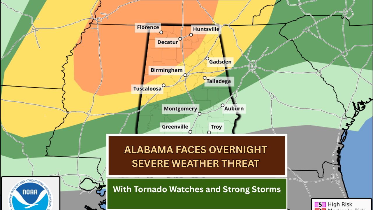
As of 10:45 p.m., a tornado watch remained active for central Alabama, set to expire at 1 a.m. Wednesday. The following counties were still under watch:
Bibb, Blount, Calhoun, Cherokee, Clay, Cleburne, Etowah, Greene, Hale, Jefferson, Pickens, Shelby, St. Clair, Sumter, Talladega, and Tuscaloosa.
Earlier in the evening, north Alabama had been included in the watch area but was later dropped as the threat diminished in those regions.
“We are keeping a close eye on lingering storms in western Alabama while stronger cells continue to move across the eastern and central parts of the state,” the NWS said in a late-night update.

Survey Teams Dispatched for Damage Assessment
The NWS in Huntsville announced plans to dispatch three survey teams starting Wednesday morning to assess damage in northern Alabama. Most of the warnings issued Tuesday were tornado-related, raising concern over the potential for widespread wind and structural damage.
Severe Weather Outlook
The Storm Prediction Center (SPC) maintained a Level 3 out of 5 (Enhanced Risk) for cities like Tuscaloosa, Birmingham, Huntsville, Gadsden, and Talladega. A Level 2 (Slight Risk) extended through Montgomery and Auburn, while Troy and Greenville were in the Level 1 (Marginal Risk) zone. Extreme south Alabama was not included in any severe threat zone.
The next SPC forecast update is expected around 1 a.m., according to officials.
“Tornadoes, including the possibility of a strong one, near-hurricane-force winds, large hail, and flooding rainfall remain possible through the night,” said forecasters.
Weather Radio Disruptions in Central Alabama
Adding to the complications, the NWS Birmingham office is in the midst of a long-planned software upgrade, which has taken NOAA Weather Radios offline for much of central Alabama.

Transmitters affected by this outage will not be able to broadcast warnings or alerts until the system upgrade is complete on Wednesday.
“Forecasts, watches, and warnings will still be issued,” NWS Birmingham clarified, “but residents should use alternate methods to receive emergency alerts.”
Residents are encouraged to rely on weather apps, television or radio broadcasts, the internet, local emergency alerts, or trusted contacts for weather updates.
Forecast Into the Overnight Hours
Forecasters anticipate that storms will gradually weaken as they move southeastward through the overnight hours. However, those in eastern Alabama should remain alert into the early morning as the risk of severe weather persists.
While much of the initial damage has been reported in north Alabama, the most dangerous conditions may still occur as the storms travel south, especially if they maintain their current strength.
What You Should Do
Officials advise Alabama residents in storm-prone areas to:
- Stay indoors and away from windows.
- Charge mobile devices and keep them nearby for alerts.
- Use weather apps that can issue real-time warnings based on your location.
- Prepare an emergency kit with flashlights, batteries, water, and non-perishable food.
- Be aware of your safest place to shelter, especially in case of tornado warnings.
This article has been carefully fact-checked by our editorial team to ensure accuracy and eliminate any misleading information. We are committed to maintaining the highest standards of integrity in our content.

Outside of work, he enjoys playing chess, following cricket, and writing short stories. His commitment to integrity and in-depth analysis strengthens OTE News’ mission of providing trustworthy journalism.